The Subsurface Toxicity and Engineering Perils of Perry’s Farmland Land-Flip
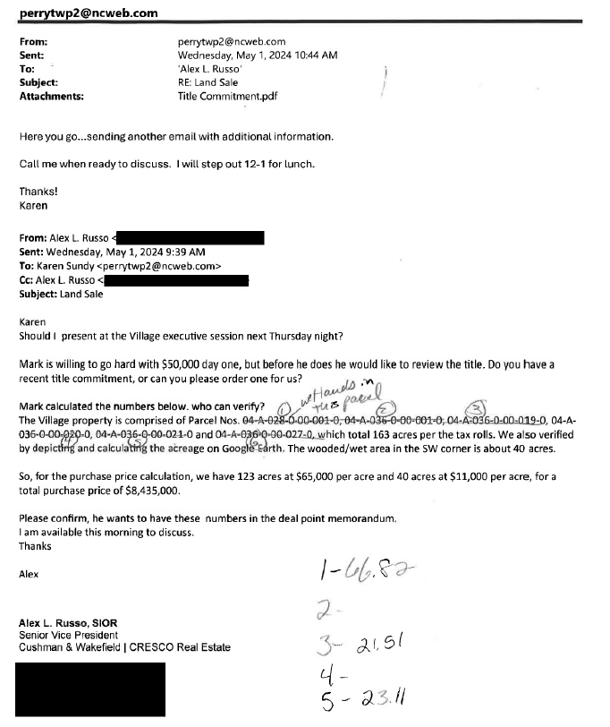
PERRY - Last month, The Ohio Register reported on the official response from Perry Village regarding a detailed public records request, specifically targeting land-use impact studies and email correspondences surrounding the development of the planned Champion Farm data center. At that time, TOR was informed by the village that it did not possess any such records, effectively arguing through omission that the nearly $9 million development deal was done on nothing but verbal conversations in executive session. TOR would like to offer anyone within the village leadership the immediate opportunity to "clarify" their official statement. The following investigative findings represent the actual documentary record.
TOR has in its possession hundreds of pages of internal emails, hand-altered sale proposals, un-filed escrow briefs, and certified engineering plats obtained through public records from concerned citizens.
The public records trail unmasks the inner administrative mechanics of the project across Perry Village, Perry Township, the Perry Joint Economic Development District (JEDD), and the Perry Local School District. Together, these entities operated under privately signed Non-Disclosure Agreements (NDA) to secure a multi-million-dollar land transaction with Newport Equities, LLC, trading ecologically sensitive regional wetlands .
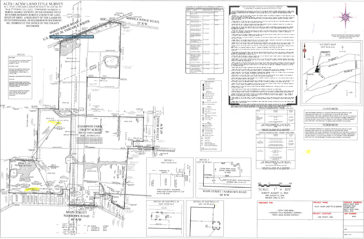
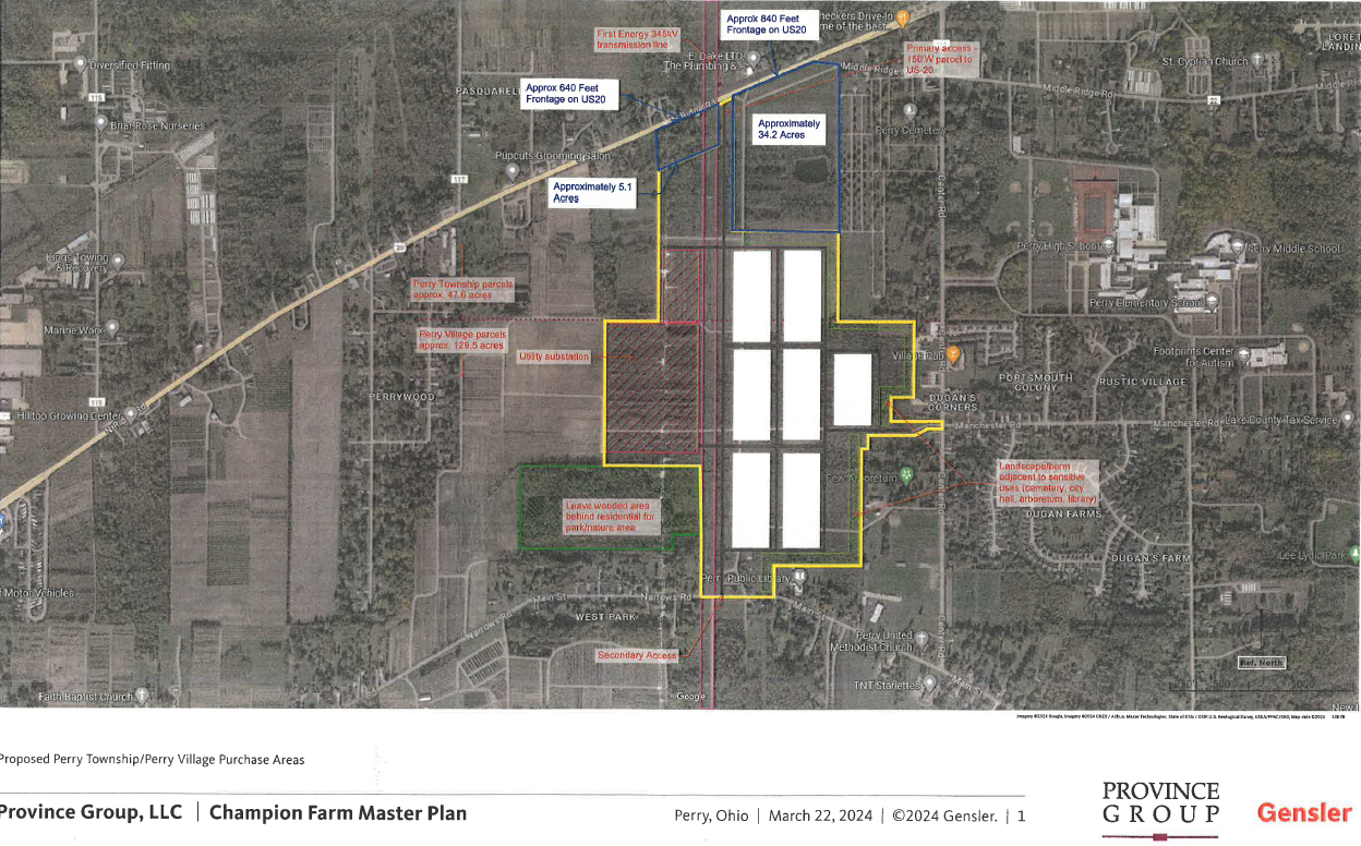
The foundational geography for the data center campus rests on the former Champion Farm property, a land plot spanning specific tax parcels including permanent parcel numbers 04-A-036-0-00-040-0, 03-A-037-0-00-019-0, 03-A-029-0-00-007-0, and 03-A-037-0-00-001-0.
The property history traces back to a foundational land transfer, Document No. 2000R036973, executed on October 5, 2000, and recorded on October 12, 2000. Signed by James W. Zampini, president of Lake County Nursery, Inc., it shows the Perry Township Board of Trustees originally acquired the core parcels for $240,000.00.
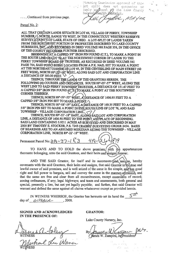
This land configuration included a 19.0838-Acre core in Lot 76 mapped by surveyor Timothy E. Stocker, P.S. 7245, keyed directly to the Township-Village Corporation Line, alongside a narrow 5.9211-Acre Village strip known as Permanent Parcel Number 04-A-036-0-00-040-0. The historical year-2000 deed carried a prominent Warning Stamp from regional oversight authorities stating that Planning Commission approval of the lot split does not guarantee or imply approval by the Lake County General Health District.
While the reasoning for this is of great importance, potentially of greater importance is the potential error performed by Perry leadership in the land deal split acquisition.
Under Ohio land-use law, there is a strict chronological order that local zoning administrators must follow, and violating this sequence creates a potential major legal vulnerability. Reviewing the certified public land filings exposes a fatal procedural mistake made by Perry Village planners.
The Perry Village Zoning Inspector officially approved and issued Zoning Permit No. 2025-169 on August 2, 2025, authorizing land usage under specialized Overlay District 1 (OD1) parameters.
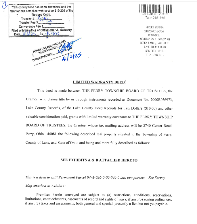
It would seem in some of the documents as if the Perry Township Board of Trustees did not legally execute and formally file the underlying boundary division deeds with Lake County Recorder Becky Lynch until August 4, 2025, at 11:49:57 AM.
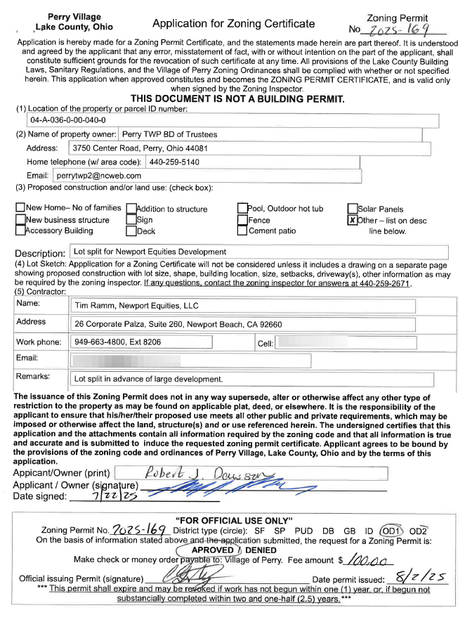
In Ohio municipal planning, a zoning inspector lacks the legal authority to issue a project-specific zoning certificate or lot-split authorization to a private developer for a parcel that does not legally exist yet under that shape.
Because the Village issued the certificate on August 2 on land that was still legally held under the old, undivided historical parent lot by the Township Trustees, the permit may be classified in land-use law as a potentially ultra vires act—meaning it was done completely outside of the inspector's statutory authority.
However, long before any data servers were envisioned, environmental geologists documented deep chemical hazards embedded in the soil and water tables across these specific coordinates.
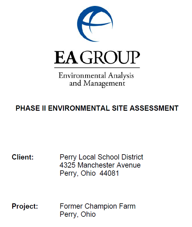
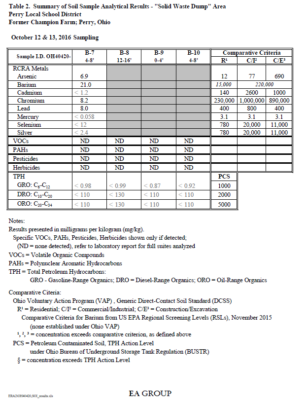
According to the October 2016 Phase II Environmental Site Assessment, severe agricultural chemical saturation remains locked within the property's upper sand units. Within the historic processing lot designated as the chicken coop area, laboratory testing isolated 420 milligrams per kilogram of 4,4-DDT. This figure drastically overshoots the state's residential direct-contact safety ceiling of 34 milligrams per kilogram, and stands well clear of the commercial land-use limit of 240 milligrams per kilogram.
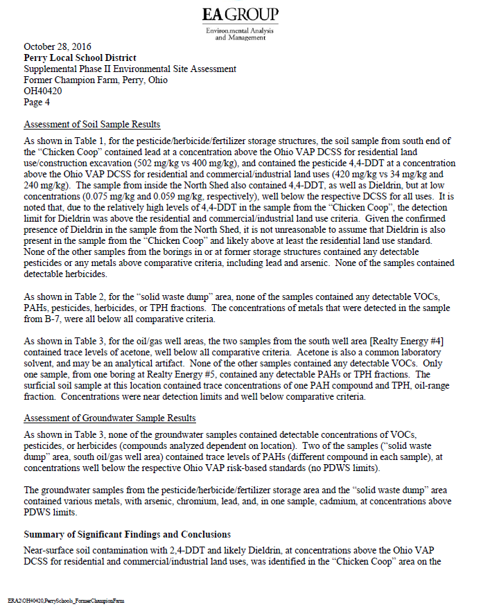
Laboratory metrics isolated near-surface lead concentrations at 502 milligrams per kilogram, crossing the state's legal direct-contact public hazard threshold of 400 milligrams per kilogram. Severe concentrations of DDT directly masked the precise laboratory detection limits for Dieldrin, a highly regulated carcinogenic chemical strongly suspected to be co-located within the site's topsoil.
Initial 2010 soil logs recorded distinct chemical pesticide and herbicide odors at shallow depths of 1 foot below grade, underneath narrow mottled clay barriers that rapidly transition into loose, highly permeable sand. Temporary groundwater monitoring units dug across the property's solid waste dump boundaries and historic storage lots demonstrated extensive contamination, failing multiple Potable Use and National Primary Drinking Water Standards.
Arsenic measured up to 0.280 milligrams per liter, exactly 28 times the legal potable limit of 0.01 milligrams per liter. Lead fluids clocked at 0.944 milligrams per liter, massively surpassing the federal statutory safety action threshold of 0.015 milligrams per liter. Chromium tracked at 0.289 milligrams per liter, nearly triple the legal limit of 0.1 milligrams per liter. Cadmium measured 0.0059 milligrams per liter, crossing the maximum regulatory health boundary of 0.005 milligrams per liter.
File reviews uncovered an underground storage tank catastrophe from 1990, where contractors excavated three leaking steel fuel units consisting of a 10,000-gallon diesel tank, a 3,000-gallon gasoline tank, and a 4,000-gallon unleaded tank, alongside a 6,000-gallon industrial heating oil repository.
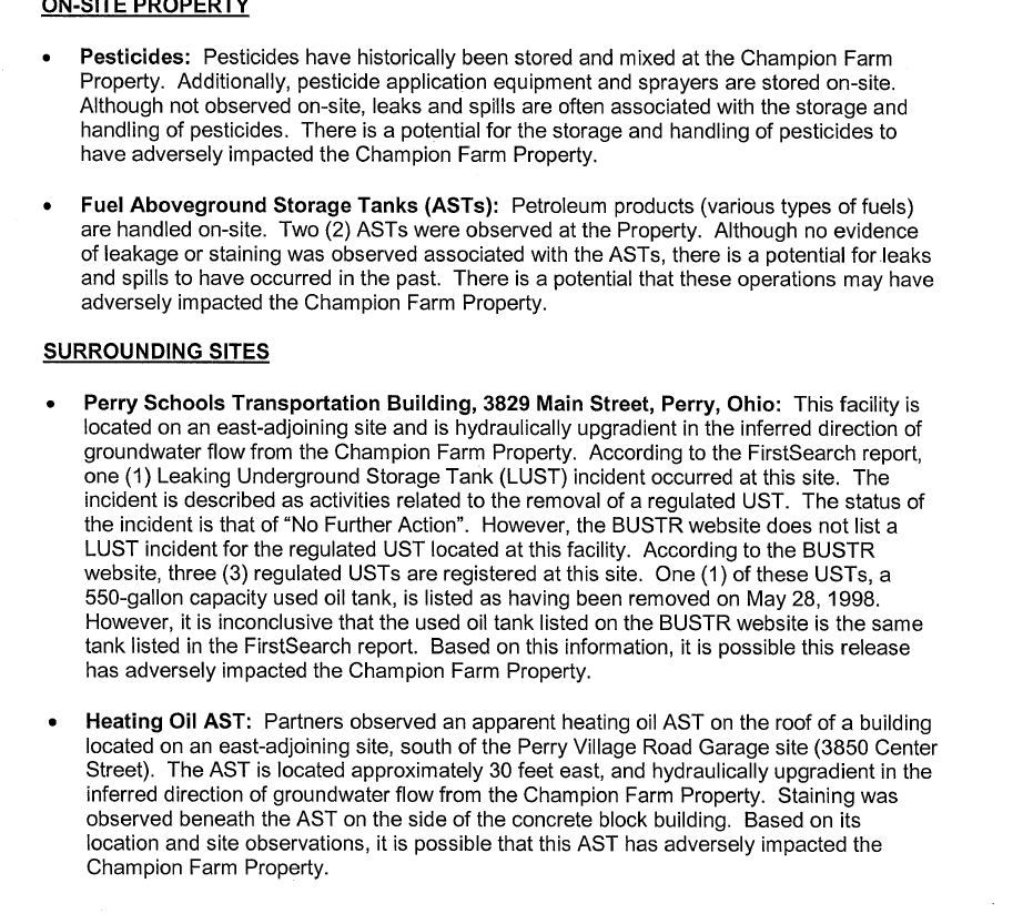
Fluid testing inside the open excavation cavity revealed liquid benzene concentrations between 0.014 parts per million and 66 parts per million, compared to a safe drinking water action cap of just 0.005 parts per million. Emergency response logs confirm that crews were forced to pump out 64,500 gallons of heavily contaminated fuel-water and remove 1,388 tons of toxic soil from the cavity. This fueling station remains fully active today. It sits less than 60 feet east of the data center's certified property boundary, presenting an ongoing upgradient risk where gravity naturally pushes subsurface leaks straight onto the development footprint. A separate building directly south of the Perry Village Road Garage at 3850 Center Street was mapped exactly 30 feet east of the property line, where state inspectors physically logged thick petroleum staining running down the concrete blocks underneath a leaky, roof-mounted heating oil storage apparatus.
The mechanical process of constructing a modern, concrete-heavy hyperscale technology campus could act as a physical catalyst, mobilizing and expanding these existing environmental hazards across the region. A 1.5-million-square-foot facility layout requires extensive excavation and site grading. When heavy scrapers cut into the chicken coop area, the dry topsoil layer will disintegrate into airborne dust, creating a public health hazard for nearby residential neighborhoods and the public library, located as close as 100 feet from the site boundaries. Continuous open-air earthmoving during seasonal rainstorms will wash loose, chemical-laden topsoil directly into the site's central drainage ditches and pond networks, bypassing natural filtration and contaminating surrounding water systems.
Data centers require dense concrete foundations supported by deep structural pilings driven far into the earth. Because the property possesses an incredibly shallow groundwater table, sitting just five to 12 feet below grade within highly porous sand units, the installation of deep structural foundation piles will act as a physical punch through the local water table. This mechanical disruption risks fracturing the natural, underlying clay containment layers that sit beneath the contaminated sand, creating an artificial conduit that allows arsenic, lead, and chromium to drain down into deeper regional aquifers.
Because trenching and utility lines must cut below the five-foot water line, foundation pits will rapidly flood with toxic groundwater. Contractors will be forced to operate high-volume, continuous dewatering pump arrays to keep concrete pours dry. This continuous extraction creates a powerful underground hydraulic vacuum, altering underground pressures and creating a suction effect that draws the 66 parts per million benzene plume from the active public bus garage straight across property lines, expanding the contamination zone.
Furthermore, if construction proceeds without comprehensive multi-million-dollar site remediation, the data center itself will face severe long-term operational risks. Constant contact with acidic, heavy-metal-dense groundwater can trigger long-term chemical reactions that structurally degrade concrete foundations over a standard 30-year operational facility lifecycle, which may be potentially disasterous given what seperate documents revealed regarding potential plans for energy generation.
Ohio EPA regulations require large industrial properties to build surface stormwater retention basins. Because these basins must be dug deep into the permeable sand, they will fill with the rising toxic groundwater table, turning the data center's mandated green infrastructure into open hazardous waste pools.
In the real-world timeline of this project, no physical environmental remediation of the soil and groundwater has officially taken place. Instead, the property has transitioned from an active real estate transaction into a stalled regulatory and political standoff. While Province Group has commissioned updated Phase I and Phase II environmental site assessments, wetlands delineation studies, and endangered species surveys, the physical extraction of contaminated soil does not begin until a developer officially closes on a land purchase and begins site grading.
The transaction remains frozen due to massive community mobilization. Grassroots resistance forced a successful citizen referendum petition drive, gathering enough signatures to place the data center zoning overlay on the ballot for a public vote. Local residents are demanding an ordinance that forces any hyperscale developer to post enforceable financial guarantees and decommissioning bonds to cover the full cost of future site cleanups.
Confronted by an upcoming public ballot challenge and intense community pushback regarding water table impacts and infrastructure strain, Province Group officially withdrew its active zoning application to re-evaluate its strategy, while Perry Village Mayor James Gessic formally resigned from office amid the escalating public scrutiny.
The scientific, historical, and geological data points exposed in this article are attributed to the following core records from the public request file:
- Property Chain of Title & Nursery Origins (2000 Baseline): The historical acquisition price of $240,000.00, the 19.0838-Acre Lot 76 shape, the 5.9211-Acre Village splice size, and the regional planning warning stamp are sourced directly from Exhibit 1: The Historical Warranty Deed , executed October 5, 2000, under Lake County Auditor Edward H. Zupancic.
- Surficial Soil Contamination Metrics: The laboratory counts of 420 mg/kg of 4,4-DDT in the "Chicken Coop" area, the 502 mg/kg Lead hot spots, and the systemic masking of Dieldrin thresholds are sourced directly from The Phase II Environmental Site Assessment (October 2016), Section 4 (Analytical Soil Logging Matrices).
- Subsurface Groundwater Action Failures: The portable water table depths of 5 to 12 feet, alongside the fluid counts of 0.280 mg/l Arsenic, 0.944 mg/l Lead, 0.289 mg/l Chromium, and 0.0059 mg/l Cadmium are sourced directly from The Phase II Environmental Site Assessment, Section 5 (Groundwater Volatile Organic Compounds Ledger).
- The Upgradient School Fuel Cavity: The 1990 school storage tank catastrophe data, including the leaking 10,000-gal diesel, 3,000-gal gasoline, 4,000-gal unleaded, and 6,000-gal heating oil tanks, the liquid Benzene count of 66 ppm, the extraction of 64,500 gallons of fuel-water, and the removal of 1,388 tons of soil are sourced directly from the regulatory file review embedded in The Phase I and II Environmental Site Assessment, Appendix B (Upgradient Environmental Vectors).